Forecast
Select a category
Africa
Clouds24Hr
LowLevelConvergence
MaximumTemperature
MeanSeaLevel24Hr
MinimumTemperature
Rainfall24Hr
UpperLevelDiversion
Windsat200hPa
Windsat500hPa
Windsat700hPa
Windsat850hPa
AndamanNicobar
CarNicobar
PortBlair
AndhraPradesh
AmravatiAP
Guntur
Tirupathi
Vijaywada
Vishakapatnam
ArunachalPradesh
Anni
Itanagar
Tawang
Assam
Barpeta
Dibrugarh
Guwahati
Silchar
Australia
Clouds24Hr
LowLevelConvergence
MaximumTemperature
MeanSeaLevel24Hr
MinimumTemperature
Rainfall24Hr
UpperLevelDiversion
Windsat200hPa
Windsat500hPa
Windsat700hPa
Windsat850hPa
Bihar
Bodhgaya
Gaya
Nalanda
Patna
Rajgir
Rohtas
Chandigarh
ChandigarhAport
ChandigarhCity
Chhatissgarh
Bilaspur
Durg
Raipur
Delhi
IGIAirport
Noida
Safdarjung
Diu
Diu
EastAsia
Clouds24Hr
LowLevelConvergence
MaximumTemperature
MeanSeaLevel24Hr
MinimumTemperature
Rainfall24Hr
UpperLevelDiversion
Windsat200hPa
Windsat500hPa
Windsat700hPa
Windsat850hPa
Eastindia
Clouds24Hr
LowLevelConvergence
MaximumTemperature
MeanSeaLevelPressure
MinimumTemperature
Rainfall24Hr
UpperLevelDiversion
Windsat200hPa
Windsat500hPa
Windsat700hPa
Windsat850hPa
Eurasia
Clouds24Hr
LowLevelConvergence
MaximumTemperature
MeanSeaLevel24Hr
MinimumTemperature
Rainfall24Hr
UpperLevelDiversion
Windsat200hPa
Windsat500hPa
Windsat700hPa
Windsat850hPa
Europe
Clouds24Hr
LowLevelConvergence
MaximumTemperature
MeanSeaLevel24Hr
MinimumTemperature
Rainfall24Hr
UpperLevelDiversion
Windsat200hPa
Windsat500hPa
Windsat700hPa
Windsat850hPa
FlyAfrica
ClearAirTurbulence
ClearAirTurbulence200hPa
ClearAirTurbulence250hPa
ClearAirTurbulence300hPa
ClearAirTurbulence350hPa
ClearAirTurbulence400hPa
ClearAirTurbulence450hPa
ClearAirTurbulence500hPa
ClearAirTurbulence550hPa
ClearAirTurbulence600hPa
FreezingLevel
Icing
Icing300hPa
Icing350hPa
Icing400hPa
Icing450hPa
Icing500hPa
Icing550hPa
Icing600hPa
Icing650hPa
Icing700hPa
JetStreamat200hPa
Winds Temperatures at 200 hPa
WindsTemperaturesat200hPa
WindsTemperaturesat500hPa
WindsTemperaturesat700hPa
WindsTemperaturesat850hPa
FlyAustralia
ClearAirTurbulence
ClearAirTurbulence200hPa
ClearAirTurbulence250hPa
ClearAirTurbulence300hPa
ClearAirTurbulence350hPa
ClearAirTurbulence400hPa
ClearAirTurbulence450hPa
ClearAirTurbulence500hPa
ClearAirTurbulence550hPa
ClearAirTurbulence600hPa
Winds&Temperaturesat500hPa
Winds&Temperaturesat700hPa
Winds&Temperaturesat850hPa
FreezingLevel
Icing
Icing300HPa
Icing350HPa
Icing400HPa
Icing450HPa
Icing500HPa
Icing600HPa
Icing650HPa
Icing700HPa
JetStreamat200hPa
WindsTemperaturesat200hPa
WindsTemperaturesat500hPa
WindsTemperaturesat700hPa
WindsTemperaturesat850hPa
FlyEastAsia
ClearAirTurbulence
ClearAirTurbulence200hPa
ClearAirTurbulence250hPa
ClearAirTurbulence300hPa
ClearAirTurbulence350hPa
ClearAirTurbulence400hPa
ClearAirTurbulence450hPa
ClearAirTurbulence500hPa
ClearAirTurbulence550hPa
ClearAirTurbulence600hPa
FreezingLevel
Icing
Icing300hPa
Icing350hPa
Icing400hPa
Icing450hPa
Icing500hPa
Icing550hPa
Icing600hPa
Icing650hPa
Icing700hPa
JetStreamat200hPa
Winds&TemperaturesAt850HPa
WindsTemperaturesAt200HPa
WindsTemperaturesAt500HPa
WindsTemperaturesat700hPa
WindsTemperaturesat850hPa
FlyEurasia
ClearAirTurbulence
ClearAirTurbulence200hPa
ClearAirTurbulence250hPa
ClearAirTurbulence300hPa
ClearAirTurbulence350hPa
ClearAirTurbulence400hPa
ClearAirTurbulence450hPa
ClearAirTurbulence500hPa
ClearAirTurbulence550hPa
ClearAirTurbulence600hPa
FreezingLevel
Icing
Icing300hPa
Icing350hPa
Icing400hPa
Icing450hPa
Icing500hPa
Icing550hPa
Icing600hPa
Icing650hPa
Icing700hPa
JetStreamat200hPa
WindsTemperaturesat200hPa
WindsTemperaturesat500hPa
WindsTemperaturesat700hPa
WindsTemperaturesat850hPa
FlyEurope
ClearAirTurbulence
ClearAirTurbulence200hPa
ClearAirTurbulence250hPa
ClearAirTurbulence300hPa
ClearAirTurbulence350hPa
ClearAirTurbulence400hPa
ClearAirTurbulence450hPa
ClearAirTurbulence500hPa
ClearAirTurbulence550hPa
ClearAirTurbulence600hPa
FreezingLevel
Icing
Icing300hPa
Icing350hPa
Icing400hPa
Icing450hPa
Icing500hPa
Icing550hPa
Icing600hPa
Icing650hPa
Icing700hPa
JetStreamat200hPa
WindsTemperaturesat200hPa
WindsTemperaturesat500hPa
WindsTemperaturesat700hPa
WindsTemperaturesat850hPa
FlyIndia
ClearAirTurbulence
ClearAirTurbulence200hPa
ClearAirTurbulence250hPa
ClearAirTurbulence300hPa
ClearAirTurbulence350hPa
ClearAirTurbulence400hPa
ClearAirTurbulence450hPa
ClearAirTurbulence500hPa
ClearAirTurbulence550hPa
ClearAirTurbulence600hPa
FreezingLevel
Icing
Icing300hPa
Icing350hPa
Icing400hPa
Icing450hPa
Icing500hPa
Icing550hPa
Icing600hPa
Icing650hPa
Icing700hPa
JetStreamat200hPa
WindsTemperaturesat200hPa
WindsTemperaturesat500hPa
WindsTemperaturesat700hPa
WindsTemperaturesat850hPa
FlyNorthAmerica
ClearAirTurbulence
ClearAirTurbulence200hPa
ClearAirTurbulence250hPa
ClearAirTurbulence300hPa
ClearAirTurbulence350hPa
ClearAirTurbulence400hPa
ClearAirTurbulence450hPa
ClearAirTurbulence500hPa
ClearAirTurbulence550hPa
ClearAirTurbulence600hPa
FreezingLevel
Icing
Icing300hPa
Icing350hPa
Icing400hPa
Icing450hPa
Icing500hPa
Icing550hPa
Icing600hPa
Icing650hPa
Icing700hPa
JetStreamat200hPa
WindsTemperaturesat200hPa
WindsTemperaturesat500hPa
WindsTemperaturesat700hPa
WindsTemperaturesat850hPa
FlySouthAmerica
ClearAirTurbulence
ClearAirTurbulence200hPa
ClearAirTurbulence250hPa
ClearAirTurbulence300hPa
ClearAirTurbulence350hPa
ClearAirTurbulence400hPa
ClearAirTurbulence450hPa
ClearAirTurbulence500hPa
ClearAirTurbulence550hPa
ClearAirTurbulence600hPa
FreezingLevel
Icing
Icing300hPa
Icing350hPa
Icing400hPa
Icing450hPa
Icing500hPa
Icing550hPa
Icing600hPa
Icing650hPa
Icing700hPa
JetStreamat200hPa
WindsTemperaturesat200hPa
WindsTemperaturesat500hPa
WindsTemperaturesat700hPa
WindsTemperaturesat850hPa
FlyWorldForecast
ClearAirTurbulence
ClearAirTurbulence200hPa
ClearAirTurbulence250hPa
ClearAirTurbulence300hPa
ClearAirTurbulence350hPa
ClearAirTurbulence400hPa
ClearAirTurbulence450hPa
ClearAirTurbulence500hPa
ClearAirTurbulence550hPa
ClearAirTurbulence600hPa
FreezingLevel
Icing
Icing300hPa
Icing350hPa
Icing400hPa
Icing450hPa
Icing500hPa
Icing550hPa
Icing600hPa
Icing650hPa
Icing700hPa
JetStreamat200hPa
WindsTemperaturesat200hPa
WindsTemperaturesat500hPa
WindsTemperaturesat700hPa
WindsTemperaturesat850hPa
Goa
Panjim
Gujarat
Ahmedabad
Dwarka
Gandhinagar
Porbandar
Surat
Veraval
Haryana
Kurukshetra
HimachalPradesh
Chamba
Dharamshala
Keylong
Kullu
Manali
Shimla
Home
India
Clouds24Hr
LowLevelConvergence
MaximumTemperature
MeanSeaLevel24Hr
MinimumTemperature
Rainfall24Hr
UpperLevelDiversion
Windsat200hPa
Windsat500hPa
Windsat700hPa
Windsat850hPa
JammuKashmir
Gulmarg
Jammu
Katra
Pahalgam
Srinagar
Jharkhand
Daltonganj
Deogarh
Giridih
Ranchi
Karnataka
Bangaluru
Kalaburgi
Mysuru
Vijaypura
Kerala
Kannur
Kochi
Kottayam
Trivandrum
Ladakh
Leh
Lakshadweep
Minicoy
MadhyaPradesh
Bhopal
Chitrakoot
Gwalior
Khajuraho
Orcha
Pachmarhi
Sanchi
Ujjain
Maharashtra
Aurangabad
Mahabaleshwar
MumbaiAirport
NagpurAirport
Nasik
Parbani
Pune
Sholapur
Manipur
Imphal
Meghalaya
Shillong
member
Mizoram
Aizwal
Champhai
Nagaland
Dimapur
Kohima
Mokokchung
NorthAmerica
Clouds24Hr
LowLevelConvergence
MaximumTemperature
MeanSeaLevel24Hr
MinimumTemperature
Rainfall24Hr
UpperLevelDiversion
Windsat200hPa
Windsat500hPa
Windsat700hPa
Windsat850hPa
Orissa
Cuttack
Dhenkanal
Gopalpur
Khordha
Nuapada
Puri
Pondicherry
Punjab
Amritsar
Anandpursahib
Mohali
Rajasthan
Ajmer
Badmer
Jaipur
Jaisalmer
Jodhpur
MountAbu
Udaipur
RenewableEnergy
RepAfrica
DewPointTemperature2m
DryBulbTemperature2m
GlobalHorizontalIrradiance
MeanSeaLevelPressure
Past24hrRainfall
RelativeHumidity2m
WindsTemperatures10m
WindsTemperatures120m
RepAustralia
DewPointTemperature2m
DryBulbTemperature2m
GlobalHorizontalIrradiance
MeanSeaLevelPressure
Past24hrRainfall
RelativeHumidity2m
WindsTemperatures10m
WindsTemperatures120m
RepEastAsia
DewPointTemperature2m
DryBulbTemperature2m
GlobalHorizontalIrradiance
MeanSeaLevelPressure
Past24hrRainfall
RelativeHumidity2m
WindsTemperatures10m
WindsTemperatures120m
RepEurasia
DewPointTemperature2m
DryBulbTemperature2m
GlobalHorizontalIrradiance
MeanSeaLevelPressure
Past24hrRainfall
RelativeHumidity2m
WindsTemperatures10m
WindsTemperatures120m
RepEurope
DewPointTemperature2m
DryBulbTemperature2m
GlobalHorizontalIrradiance
MeanSeaLevelPressure
Past24hrRainfall
RelativeHumidity2m
WindsTemperatures10m
WindsTemperatures120m
RepIndia
DewPointTemperature2m
DryBulbTemperature2m
GlobalHorizontalIrradiance
MeanSeaLevelPressure
Past24hrRainfall
RelativeHumidity2m
WindsTemperatures10m
WindsTemperatures120m
RepNorthAmerica
DewPointTemperature2m
DryBulbTemperature2m
GlobalHorizontalIrradiance
MeanSeaLevelPressure
Past24hrRainfall
RelativeHumidity2m
WindsTemperatures10m
WindsTemperatures120m
RepSouthAmerica
DewPointTemperature2m
DryBulbTemperature2m
GlobalHorizontalIrradiance
MeanSeaLevelPressure
Past24hrRainfall
RelativeHumidity2m
WindsTemperatures10m
WindsTemperatures120m
RepWorld
DewPointTemperature2m
DryBulbTemperature2m
GlobalHorizontalIrradiance
MeanSeaLevelPressure
Past24hrRainfall
RelativeHumidity2m
WindsTemperatures10m
WindsTemperatures120m
Sikkim
Gangtok
Gyalsingh
Namchi
SouthAmerica
Clouds24Hr
LowLevelConvergence
MaximumTemperature
MeanSeaLevel24Hr
MinimumTemperature
Rainfall24Hr
UpperLevelDiversion
Windsat200hPa
Windsat500hPa
Windsat700hPa
Windsat850hPa
Southindia
Clouds24Hr
LowLevelConvergence
MaximumTemperature
MeanSeaLevelPressure
MinimumTemperature
Rainfall24Hr
UpperLevelDiversion
Windsat200hPa
Windsat500hPa
Windsat700hPa
Windsat850hPa
T20IWorldCup
Colombo
Kandy
TamilNadu
Chennai
Coimbatore
Kanyakumari
Koidaikanal
Kotagiri
Madurai
Ooty
Tiruchirapalli
Telangana
Hyderabad
Nizamabad
Tripura
Agartala
Uncategorized
UttarPradesh
Agra
Bareilly
Gorakhpur
jhansi
Jhansiti
Kanpur
Lucknow
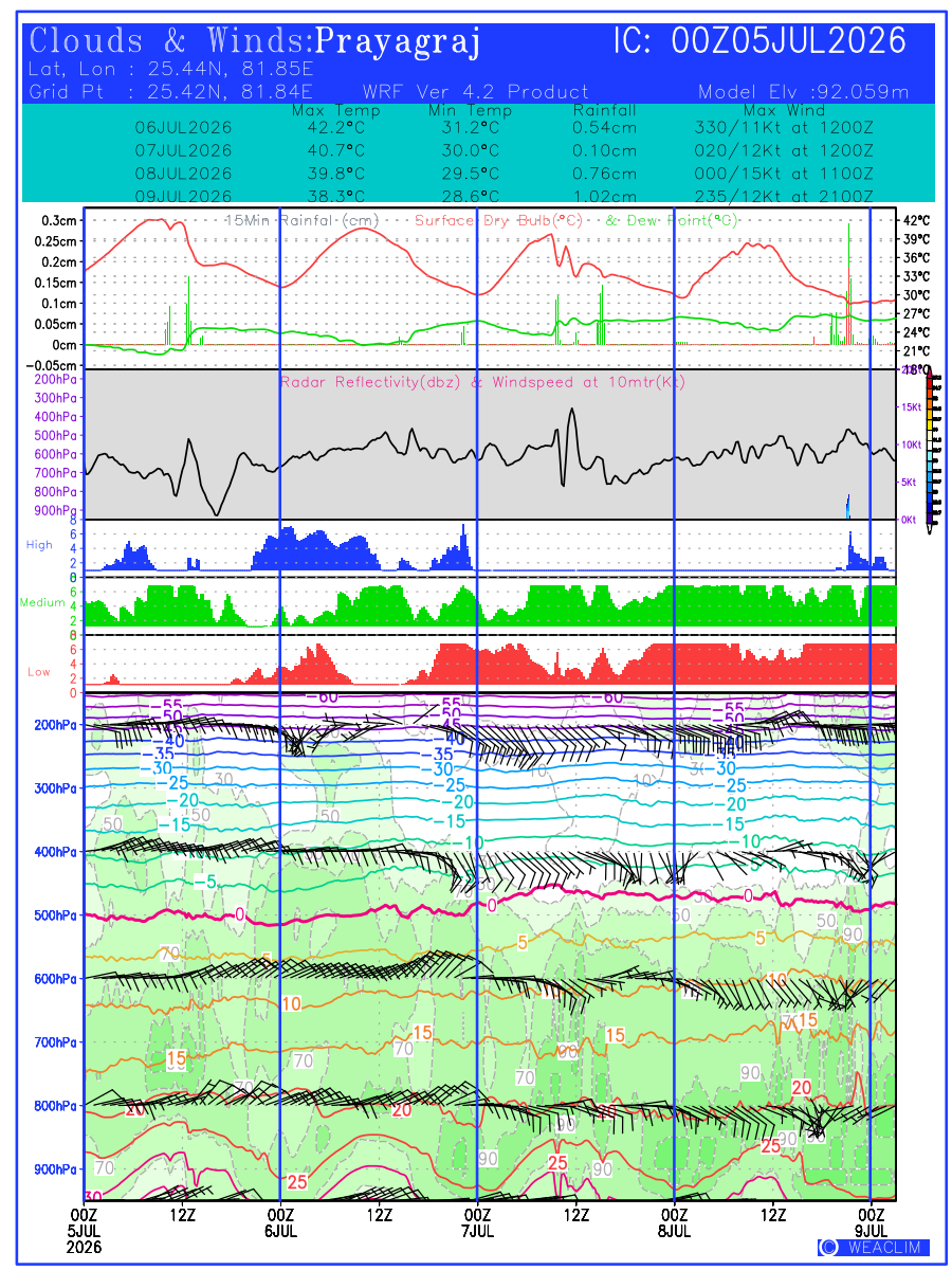
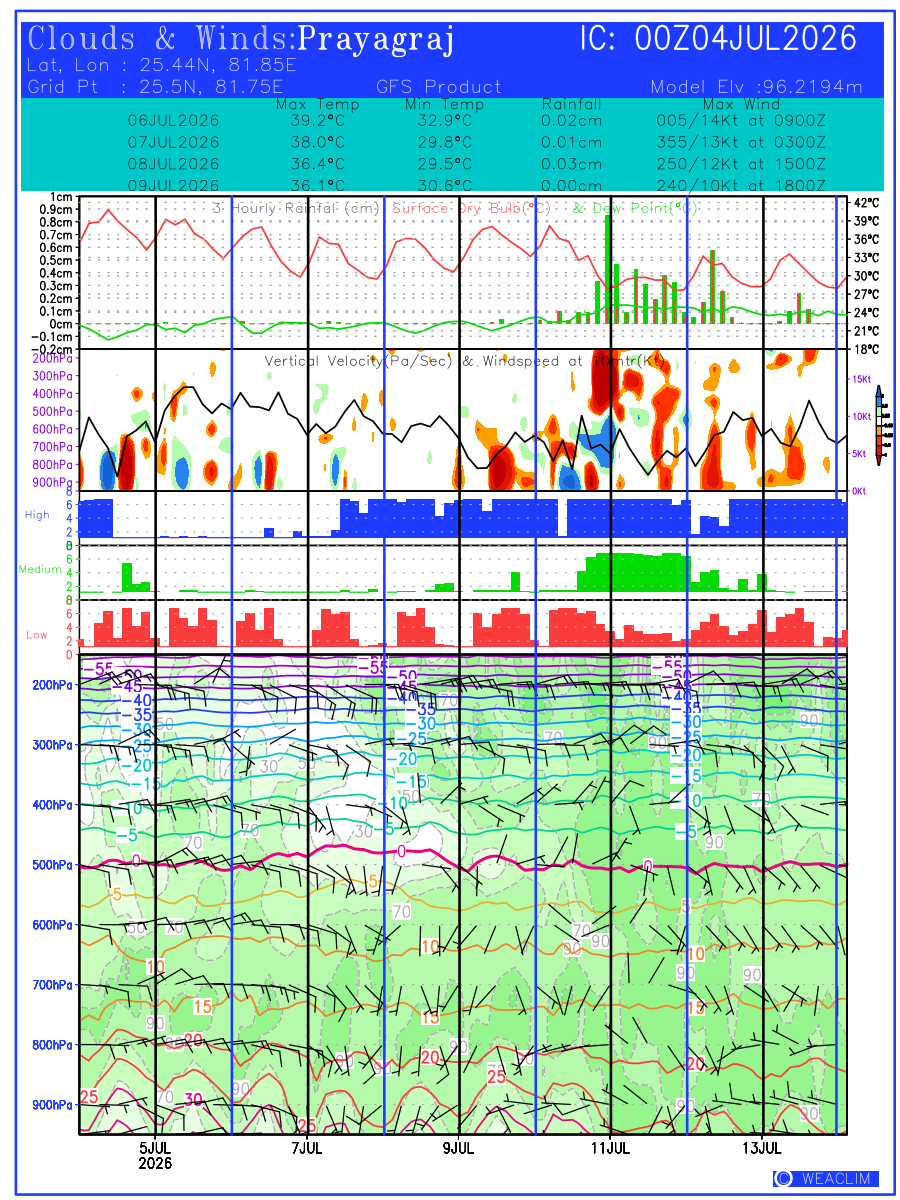
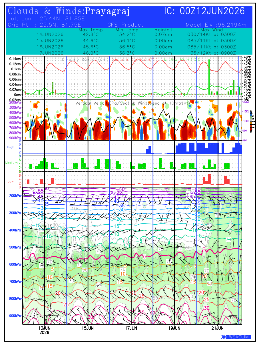
Prayagraj
Varanasi
Uttrakhand
Badrinath
Chamoli
Dehradun
Haridwar
Joshimath
Kedarnath
mussoorie
Mussoorie
Nainital
WestBengal
Bagdogra
Darjeeling
Digha
Jalpaiguri
Kolkata
Sriniketan
Westindia
Clouds24Hr
LowLevelConvergence
MaximumTemperature
MeanSeaLevelPressure
MinimumTemperature
Rainfall24Hr
UpperLevelDiversion
Windsat200hPa
Windsat500hPa
Windsat700hPa
Windsat850hPa
World
UK
WorldForecast
Clouds24Hr
LowLevelConvergence
MaximumTemperature
MeanSeaLevel24Hr
MinimumTemperature
Rainfall24Hr
UpperLevelDiversion
Windsat200hPa
Windsat500hPa
Windsat700hPa
Windsat850hPa
WRF15km
Clouds24Hr
LowLevelConvergence
MaximumTemperature
MeanSeaLevelPressure
MinimumTemperature
Rainfall24Hr
REProducts
DewPointTemperature2m
DryBulbTemperature2m
GlobalHorizontalIrradiance
Past24hrRainfall
RelativeHumidity2m
ReMeanSeaLevelPressure
WindsTemperatures10m
WindsTemperatures120m
UpperLevelDiversion
Windsat200hPa
Windsat500hPa
Windsat700hPa
Windsat850hPa
WRF45km
Clouds24Hr
LowLevelConvergence
MaximumTemperature
MeanSeaLevelPressure
MinimumTemperature
Rainfall24Hr
REProducts
DewPointTemperature2m
DryBulbTemperature2m
GlobalHorizontalIrradiance
Past24hrRainfall
RelativeHumidity2m
ReMeanSeaLevelPressure
WindsTemperatures10m
WindsTemperatures120m
UpperLevelDiversion
Windsat200hPa
Windsat500hPa
Windsat700hPa
Windsat850hPa