| GFS Analysis | Initialized with #NCEP #GFS 23rd January 2026 / 0000 UTC | Valid till 02nd February 2026 / 0000 UTC | Inputs from #IMD, New Delhi |
⏱️ Synoptic Features:
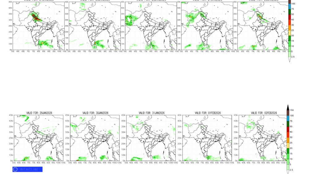
🔺Present Western Disturbance (WD) persists over J&K till 24th January. Fresh Active WD moves to J&K on 26th January to affect Western Himalayas and adjoining Nepal till 28th January.
🔺Trough of Low Pressures moves across South Indian Peninsula during 24th to 28th January 2026. Next one appears again over Andaman Sea on 28th and reaches Tamil Nadu by 31st January.
🌧️ Rainfall Outlook:
🔺North India: Rain/Snow over the Western Himalayas in association with present WD will wane off today. Fairly-widespread Rain/Snowfall with isolated heavy spells will occur over J&K, Himachal Pradesh, Uttarakhand and adjoining northern plains between 26th to 28th January 2026.
🔺West, Central & Indo Gangetic Plains: Generally, cloud free skies will prevail over these regions with Dense Fog/Smog and Mist activity mainly during morning hours of the forecast period.
🔺South Peninsula: Scattered light/moderate rainfall will occur over Tamil Nadu and adjoining regions between 24th to 28th January. Next spell occurs sequentially from South Andaman Islands on 28th January, across to South-central Bay of Bengal and then over South Tamil Nadu and adjoining Sri Lanka between 31st January to 02nd February 2026.
🌡️ Temperature Trends: Sub zero temperatures persists over the Western Himalayas, whereas temperatures rise significantly over the Plains of entire Indian Subcontinent.
🔺 Minimum: 00-05°C over Punjab till 25th January; 05-10°C Plains of North and Northwest till 26th January. Thereafter, 10-15°C over Plains of North, Northwest, West India, Indo Gangetic Plains and East India; 15-20°C Central India, 20-25°C over Central & South India.
🔺 Maximum: 15-20°C over Plains of North and Northwest India till 26th January. Thereafter, Max temperatures rise to 20-25°C over Plains of North, Northwest, West India, Indo Gangetic Plains and East India; 25-30°C over Central & South India.