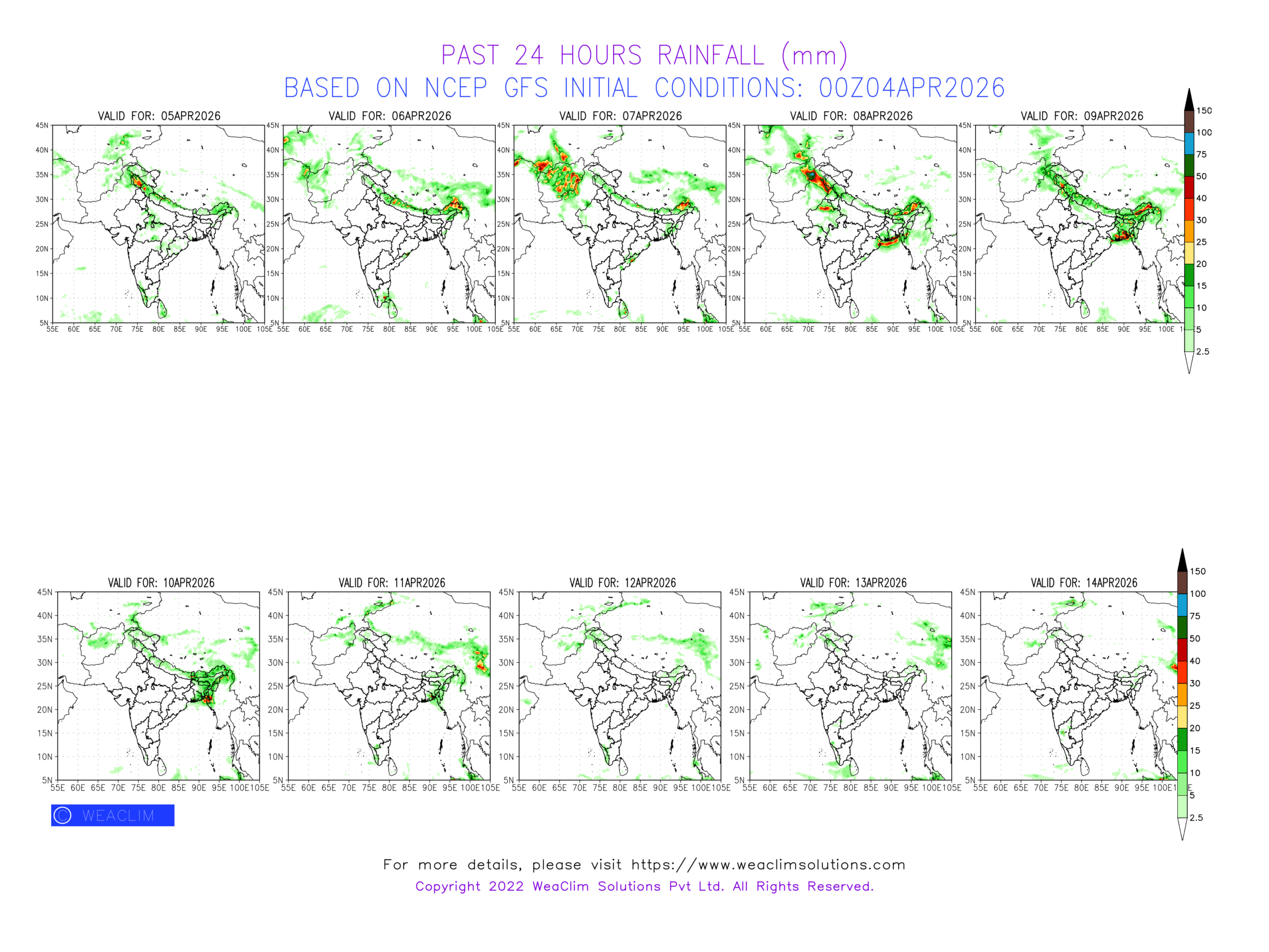
⏱️ Synoptic Features:
🔺Western Disturbance lies over North & Central Pakistan and neighbouring regions of India as cyclonic circulation in middle tropospheric levels. It affects North and Northwest India between 05th-06th April.
🔺Another Western Disturbance affects Northwest India between 07th-09th April, 2026.
🔺Remnants of these systems are seen over Northeast India and adjoining Bangladesh between 07th-08th and 09th-11th April 2026.
🔺Subtropical Westerly Jet Stream with core winds greater 90 knots at 200hPa reaches as South as 20°S as it meanders eastwards along with deep amplitude westerly trough across North, Central and Northeast India, between 05th-10th April, generally to the rear of the WDs providing upper air diversion to the low level circulations.
🔺Upper-air cyclonic circulations lie over Rajasthan, Chhattisgarh, Telangana and North Interior Karnataka at 850hPa mainly during the initial part of the forecast period.
🌧️ Rainfall Outlook:
🔺North & North West India: Fairly-widespread light/moderate rainfall/snowfall with scattered thunderstorm/hailstorm over Western Himalayas during 05th-06th and 07th-09th April with scattered heavy spells over Jammu-Kashmir-Ladakh and Himachal Pradesh.
🔺Scattered rainfall with isolated thunderstorm, occurs over Punjab, Rajasthan, Haryana, Chandigarh, Delhi and West UP during 05th-06th and 07th-09th April. Second spell causes scattered heavy spells over North Rajasthan, Haryana and adjoining Delhi NCR.
🔺North East India: Fairly widespread light/moderate rain/thunderstorms over Nepal, Sub Himalayan West Bengal, Sikkim and Bhutan with scattered heavy spells over Assam and Arunachal Pradesh during 07th-08th April. During 09th-11th April the activity spread to Bangladesh and adjoining Gangetic West Bengal with scattered heavy spells.
🔺Central India: Scattered moderate rainfall will occur over Madhya Maharashtra and Madhya Pradesh during 05th-06th April.
🔺East India: Moderate rain/thunderstorms over Gangetic West Bengal, Chhattisgarh, Odisha and Bangladesh during 09th-11th April..
🔺South Peninsular India: Scattered light rainfall will occur over Kerala and adjoining Tamil Nadu during 05th-07th and 11th-14th April.
🔺West India: No significant activity.
🌡️ Temperature Trends:
🔺 Minimum: 15-20°C over Plains of North, Northwest; 20-25°C West India, Indo Gangetic Plains, Central and South India, rising to 25-30°C during later part of the forecast period.
🔺 Maximum: 25-30°C over Plains of North, Northwest India; 30-35°C over West India, Indo Gangetic Plains, Central and South India with pockets of 35-40°C over Eastern Coast of India.
Predicted pattern of rainfall / snowfall during the next ten days along with predicted pattern of Radiation Fog over the northern plains of India (in experimental mode) using the concept of Cross Over Temperature, Fog Stability Index and Modified Richardson Index have been discussed in the following post. Read the post for more details. Thanx and Regards.
https://lnkd.in/grsmyfpd